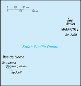
The Geography of Wallis and Futuna
The Geography of Wallis and Futuna
Wallisian, Futunan, or Wallis an Geography
Location: Oceania, islands in the South Pacific Ocean, about two-thirds of the way from Hawaii to New Zealand
Geographic coordinates: 13 18 S, 176 12 W
Map references: Oceania
Area: total: 274 sq km land: 274 sq km water: 0 sq km note: includes Ile Uvea (Wallis Island), Ile Futuna (Futuna Island), Ile Alofi, and 20 islets
Area - comparative: 1.5 times the size of Washington, DC
Land boundaries: 0 km
Coastline: 129 km
Maritime claims: territorial sea: 12 nm exclusive economic zone: 200 nm
Climate: tropical; hot, rainy season (November to April); cool, dry season (May to October); rains 2,500-3,000 mm per year (80% humidity); average temperature 26.6 degrees C
Terrain: volcanic origin; low hills
Elevation extremes: lowest point: Pacific Ocean 0 m highest point: Mont Singavi (on Futuna) 765 m
Natural resources: NEGL
Land use: arable land: 7.14% permanent crops: 35.71% other: 57.15% (2005)
Irrigated land: NA
Natural hazards: NA
Environment - current issues: deforestation (only small portions of the original forests remain) largely as a result of the continued use of wood as the main fuel source; as a consequence of cutting down the forests, the mountainous terrain of Futuna is particularly prone to erosion; there are no permanent settlements on Alofi because of the lack of natural fresh water resources
Environment - international agreements:
Geography - note: both island groups have fringing reefs


