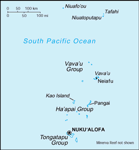
The Geography of Tonga
The Geography of Tonga
Tongan Geography
Location: Oceania, archipelago in the South Pacific Ocean, about two-thirds of the way from Hawaii to New Zealand
Geographic coordinates: 20 00 S, 175 00 W
Map references: Oceania
Area: total: 748 sq km land: 718 sq km water: 30 sq km
Area - comparative: four times the size of Washington, DC
Land boundaries: 0 km
Coastline: 419 km
Maritime claims: territorial sea: 12 nm exclusive economic zone: 200 nm continental shelf: 200 m depth or to the depth of exploitation
Climate: tropical; modified by trade winds; warm season (December to May), cool season (May to December)
Terrain: most islands have limestone base formed from uplifted coral formation; others have limestone overlying volcanic base
Elevation extremes: lowest point: Pacific Ocean 0 m highest point: unnamed location on Kao Island 1,033 m
Natural resources: fish, fertile soil
Land use: arable land: 20% permanent crops: 14.67% other: 65.33% (2005)
Irrigated land: NA
Natural hazards: cyclones (October to April); earthquakes and volcanic activity on Fonuafo'ou
Environment - current issues: deforestation results as more and more land is being cleared for agriculture and settlement; some damage to coral reefs from starfish and indiscriminate coral and shell collectors; overhunting threatens native sea turtle populations
Environment - international agreements: party to: Biodiversity, Climate Change, Climate Change-Kyoto Protocol, Desertification, Law of the Sea, Marine Dumping, Marine Life Conservation, Ozone Layer Protection, Ship Pollution signed, but not ratified: none of the selected agreements
Geography - note: archipelago of 169 islands (36 inhabited)


