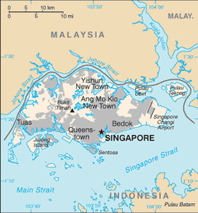
The Geography of Singapore
The Geography of Singapore
Singapore Geography
Location: Southeastern Asia, islands between Malaysia and Indonesia
Geographic coordinates: 1 22 N, 103 48 E
Map references: Southeast Asia
Area: total: 692.7 sq km land: 682.7 sq km water: 10 sq km
Area - comparative: slightly more than 3.5 times the size of Washington, DC
Land boundaries: 0 km
Coastline: 193 km
Maritime claims: territorial sea: 3 nm exclusive fishing zone: within and beyond territorial sea, as defined in treaties and practice
Climate: tropical; hot, humid, rainy; two distinct monsoon seasons - Northeastern monsoon (December to March) and Southwestern monsoon (June to September); inter-monsoon - frequent afternoon and early evening thunderstorms
Terrain: lowland; gently undulating central plateau contains water catchment area and nature preserve
Elevation extremes: lowest point: Singapore Strait 0 m highest point: Bukit Timah 166 m
Natural resources: fish, deepwater ports
Land use: arable land: 1.47% permanent crops: 1.47% other: 97.06% (2005)
Irrigated land: NA
Natural hazards: NA
Environment - current issues: industrial pollution; limited natural fresh water resources; limited land availability presents waste disposal problems; seasonal smoke/haze resulting from forest fires in Indonesia
Environment - international agreements: party to: Biodiversity, Climate Change, Climate Change-Kyoto Protocol, Desertification, Endangered Species, Hazardous Wastes, Law of the Sea, Ozone Layer Protection, Ship Pollution signed, but not ratified: none of the selected agreements
Geography - note: focal point for Southeast Asian sea routes


