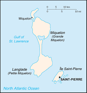
The Geography of Saint Pierre and Miquelon
The Geography of Saint Pierre and Miquelon
French Geography
Location: Northern North America, islands in the North Atlantic Ocean, south of Newfoundland (Canada)
Geographic coordinates: 46 50 N, 56 20 W
Map references: North America
Area: total: 242 sq km land: 242 sq km water: 0 sq km note: includes eight small islands in the Saint Pierre and the Miquelon groups
Area - comparative: 1.5 times the size of Washington, DC
Land boundaries: 0 km
Coastline: 120 km
Maritime claims: territorial sea: 12 nm exclusive economic zone: 200 nm
Climate: cold and wet, with much mist and fog; spring and autumn are windy
Terrain: mostly barren rock
Elevation extremes: lowest point: Atlantic Ocean 0 m highest point: Morne de la Grande Montagne 240 m
Natural resources: fish, deepwater ports
Land use: arable land: 12.5% permanent crops: 0% other: 87.5% (2005)
Irrigated land: NA
Natural hazards: persistent fog throughout the year can be a maritime hazard
Environment - current issues: recent test drilling for oil in waters around Saint Pierre and Miquelon may bring future development that would impact the environment
Environment - international agreements:
Geography - note: vegetation scanty


