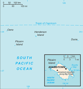
The Geography of Pitcairn Islands
The Geography of Pitcairn Islands
Pitcairn Islander Geography
Location: Oceania, islands in the South Pacific Ocean, about midway between Peru and New Zealand
Geographic coordinates: 25 04 S, 130 06 W
Map references: Oceania
Area: total: 47 sq km land: 47 sq km water: 0 sq km
Area - comparative: about 0.3 times the size of Washington, DC
Land boundaries: 0 km
Coastline: 51 km
Maritime claims: territorial sea: 3 nm exclusive economic zone: 200 nm
Climate: tropical; hot and humid; modified by southeast trade winds; rainy season (November to March)
Terrain: rugged volcanic formation; rocky coastline with cliffs
Elevation extremes: lowest point: Pacific Ocean 0 m highest point: Pawala Valley Ridge 347 m
Natural resources: miro trees (used for handicrafts), fish note: manganese, iron, copper, gold, silver, and zinc have been discovered offshore
Land use: arable land: NA permanent crops: NA other: NA
Irrigated land: NA
Natural hazards: typhoons (especially November to March)
Environment - current issues: deforestation (only a small portion of the original forest remains because of burning and clearing for settlement)
Environment - international agreements:
Geography - note: Britain's most isolated dependency; only the larger island of Pitcairn is inhabited but it has no port or natural harbor; supplies must be transported by rowed longboat from larger ships stationed offshore


