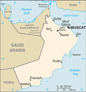
The Geography of Oman
The Geography of Oman
Omani Geography
Location: Middle East, bordering the Arabian Sea, Gulf of Oman, and Persian Gulf, between Yemen and UAE
Geographic coordinates: 21 00 N, 57 00 E
Map references: Middle East
Area: total: 212,460 sq km land: 212,460 sq km water: 0 sq km
Area - comparative: slightly smaller than Kansas
Land boundaries: total: 1,374 km border countries: Saudi Arabia 676 km, UAE 410 km, Yemen 288 km
Coastline: 2,092 km
Maritime claims: territorial sea: 12 nm contiguous zone: 24 nm exclusive economic zone: 200 nm
Climate: dry desert; hot, humid along coast; hot, dry interior; strong southwest summer monsoon (May to September) in far south
Terrain: central desert plain, rugged mountains in north and south
Elevation extremes: lowest point: Arabian Sea 0 m highest point: Jabal Shams 2,980 m
Natural resources: petroleum, copper, asbestos, some marble, limestone, chromium, gypsum, natural gas
Land use: arable land: 0.12% permanent crops: 0.14% other: 99.74% (2005)
Irrigated land: 720 sq km (2003)
Natural hazards: summer winds often raise large sandstorms and dust storms in interior; periodic droughts
Environment - current issues: rising soil salinity; beach pollution from oil spills; limited natural fresh water resources
Environment - international agreements: party to: Biodiversity, Climate Change, Climate Change-Kyoto Protocol, Desertification, Hazardous Wastes, Law of the Sea, Marine Dumping, Ozone Layer Protection, Ship Pollution, Whaling signed, but not ratified: none of the selected agreements
Geography - note: strategic location on Musandam Peninsula adjacent to Strait of Hormuz, a vital transit point for world crude oil


