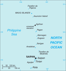
The Geography of Northern Mariana Islands
The Geography of Northern Mariana Islands
NA Geography
Location: Oceania, islands in the North Pacific Ocean, about three-quarters of the way from Hawaii to the Philippines
Geographic coordinates: 15 12 N, 145 45 E
Map references: Oceania
Area: total: 477 sq km land: 477 sq km water: 0 sq km note: consists of 14 islands including Saipan, Rota, and Tinian
Area - comparative: 2.5 times the size of Washington, DC
Land boundaries: 0 km
Coastline: 1,482 km
Maritime claims: territorial sea: 12 nm exclusive economic zone: 200 nm
Climate: tropical marine; moderated by northeast trade winds, little seasonal temperature variation; dry season December to June, rainy season July to October
Terrain: southern islands are limestone with level terraces and fringing coral reefs; northern islands are volcanic
Elevation extremes: lowest point: Pacific Ocean 0 m highest point: unnamed location on Agrihan 965 m
Natural resources: arable land, fish
Land use: arable land: 13.04% permanent crops: 4.35% other: 82.61% (2005)
Irrigated land: NA
Natural hazards: active volcanoes on Pagan and Agrihan; typhoons (especially August to November)
Environment - current issues: contamination of groundwater on Saipan may contribute to disease; clean-up of landfill; protection of endangered species conflicts with development
Environment - international agreements:
Geography - note: strategic location in the North Pacific Ocean


