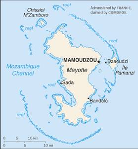
The Geography of Mayotte
The Geography of Mayotte
Mahoran Geography
Location: Southern Indian Ocean, island in the Mozambique Channel, about half way between northern Madagascar and northern Mozambique
Geographic coordinates: 12 50 S, 45 10 E
Map references: Africa
Area: total: 374 sq km land: 374 sq km water: 0 sq km
Area - comparative: slightly more than twice the size of Washington, DC
Land boundaries: 0 km
Coastline: 185.2 km
Maritime claims: territorial sea: 12 nm exclusive economic zone: 200 nm
Climate: tropical; marine; hot, humid, rainy season during northeastern monsoon (November to May); dry season is cooler (May to November)
Terrain: generally undulating, with deep ravines and ancient volcanic peaks
Elevation extremes: lowest point: Indian Ocean 0 m highest point: Benara 660 m
Natural resources: NEGL
Land use: arable land: NA% permanent crops: NA% other: NA%
Irrigated land: NA
Natural hazards: cyclones during rainy season
Environment - current issues: NA
Environment - international agreements:
Geography - note: part of Comoro Archipelago (18 islands)


