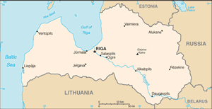
The Geography of Latvia
The Geography of Latvia
Latvian Geography
Location: Eastern Europe, bordering the Baltic Sea, between Estonia and Lithuania
Geographic coordinates: 57 00 N, 25 00 E
Map references: Europe
Area: total: 64,589 sq km land: 63,589 sq km water: 1,000 sq km
Area - comparative: slightly larger than West Virginia
Land boundaries: total: 1,382 km border countries: Belarus 171 km, Estonia 343 km, Lithuania 576 km, Russia 292 km
Coastline: 498 km
Maritime claims: territorial sea: 12 nm exclusive economic zone: 200 nm continental shelf: 200 m depth or to the depth of exploitation
Climate: maritime; wet, moderate winters
Terrain: low plain
Elevation extremes: lowest point: Baltic Sea 0 m highest point: Galzina Kalns 312 m
Natural resources: peat, limestone, dolomite, amber, hydropower, wood, arable land
Land use: arable land: 28.19% permanent crops: 0.45% other: 71.36% (2005)
Irrigated land: 200 sq km note: land in Latvia is often too wet and in need of drainage not irrigation; approximately 16,000 sq km or 85% of agricultural land has been improved by drainage (2003)
Natural hazards: NA
Environment - current issues: Latvia's environment has benefited from a shift to service industries after the country regained independence; the main environmental priorities are improvement of drinking water quality and sewage system, household, and hazardous waste management, as well as reduction of air pollution; in 2001, Latvia closed the EU accession negotiation chapter on environment committing to full enforcement of EU environmental directives by 2010
Environment - international agreements: party to: Air Pollution, Air Pollution-Persistent Organic Pollutants, Biodiversity, Climate Change, Climate Change-Kyoto Protocol, Desertification, Endangered Species, Hazardous Wastes, Law of the Sea, Ozone Layer Protection, Ship Pollution, Wetlands signed, but not ratified: none of the selected agreements
Geography - note: most of the country is composed of fertile, low-lying plains, with some hills in the east


