The Geography of Kosovo
The Geography of Kosovo
Kosovar (Albanian), Kosovski (Se Geography
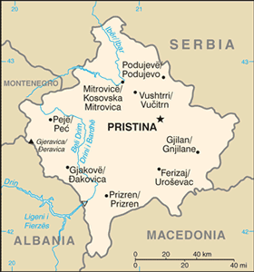
Location: Southeast Europe, between Serbia and Macedonia
Geographic coordinates: 42 35 N, 21 00 E
Map references: Europe
Area: total: 10,887 sq km land: 10,887 sq km water: 0 sq km
Area - comparative: slightly larger than Delaware
Land boundaries: total: 702 km border countries: Albania 112 km, Macedonia 159 km, Montenegro 79 km, Serbia 352 km
Coastline: 0 km (landlocked)
Maritime claims: none (landlocked)
Climate: influenced by continental air masses resulting in relatively cold winters with heavy snowfall and hot, dry summers and autumns; Mediterranean and alpine influences create regional variation; maximum rainfall between October and December
Terrain: flat fluvial basin with an elevation of 400-700 m above sea level surrounded by several high mountain ranges with elevations of 2,000 to 2,500 m
Elevation extremes: lowest point: Drini i Bardhe/Beli Drim 297 m (located on the border with Albania) highest point: Gjeravica/Deravica 2,656 m
Natural resources: nickel, lead, zinc, magnesium, lignite, kaolin, chrome, bauxite
Land use:
Irrigated land:
Natural hazards:
Environment - current issues:
Environment - international agreements:
Geography - note:


