The Geography of Gabon
The Geography of Gabon
Gabonese Geography
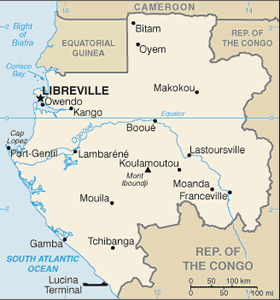
Location: Western Africa, bordering the Atlantic Ocean at the Equator, between Republic of the Congo and Equatorial Guinea
Geographic coordinates: 1 00 S, 11 45 E
Map references: Africa
Area: total: 267,667 sq km land: 257,667 sq km water: 10,000 sq km
Area - comparative: slightly smaller than Colorado
Land boundaries: total: 2,551 km border countries: Cameroon 298 km, Republic of the Congo 1,903 km, Equatorial Guinea 350 km
Coastline: 885 km
Maritime claims: territorial sea: 12 nm contiguous zone: 24 nm exclusive economic zone: 200 nm
Climate: tropical; always hot, humid
Terrain: narrow coastal plain; hilly interior; savanna in east and south
Elevation extremes: lowest point: Atlantic Ocean 0 m highest point: Mont Iboundji 1,575 m
Natural resources: petroleum, natural gas, diamond, niobium, manganese, uranium, gold, timber, iron ore, hydropower
Land use: arable land: 1.21% permanent crops: 0.64% other: 98.15% (2005)
Irrigated land: 70 sq km (2003)
Natural hazards: NA
Environment - current issues: deforestation; poaching
Environment - international agreements: party to: Biodiversity, Climate Change, Climate Change-Kyoto Protocol, Desertification, Endangered Species, Hazardous Wastes, Law of the Sea, Marine Dumping, Ozone Layer Protection, Ship Pollution, Tropical Timber 83, Tropical Timber 94, Wetlands, Whaling signed, but not ratified: none of the selected agreements
Geography - note: a small population and oil and mineral reserves have helped Gabon become one of Africa's wealthier countries; in general, these circumstances have allowed the country to maintain and conserve its pristine rain forest and rich biodiversity


