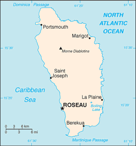
The Geography of Dominica
The Geography of Dominica
Dominican Geography
Location: Caribbean, island between the Caribbean Sea and the North Atlantic Ocean, about half way between Puerto Rico and Trinidad and Tobago
Geographic coordinates: 15 25 N, 61 20 W
Map references: Central America and the Caribbean
Area: total: 754 sq km land: 754 sq km water: 0 sq km
Area - comparative: slightly more than four times the size of Washington, DC
Land boundaries: 0 km
Coastline: 148 km
Maritime claims: territorial sea: 12 nm contiguous zone: 24 nm exclusive economic zone: 200 nm
Climate: tropical; moderated by northeast trade winds; heavy rainfall
Terrain: rugged mountains of volcanic origin
Elevation extremes: lowest point: Caribbean Sea 0 m highest point: Morne Diablatins 1,447 m
Natural resources: timber, hydropower, arable land
Land use: arable land: 6.67% permanent crops: 21.33% other: 72% (2005)
Irrigated land: NA
Natural hazards: flash floods are a constant threat; destructive hurricanes can be expected during the late summer months
Environment - current issues: NA
Environment - international agreements: party to: Biodiversity, Climate Change, Climate Change-Kyoto Protocol, Desertification, Endangered Species, Environmental Modification, Hazardous Wastes, Law of the Sea, Ozone Layer Protection, Ship Pollution, Whaling signed, but not ratified: none of the selected agreements
Geography - note: known as "The Nature Island of the Caribbean" due to its spectacular, lush, and varied flora and fauna, which are protected by an extensive natural park system; the most mountainous of the Lesser Antilles, its volcanic peaks are cones of lava craters and include Boiling Lake, the second-largest, thermally active lake in the world


