The Geography of Cuba
The Geography of Cuba
Cuban Geography
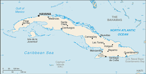
Location: Caribbean, island between the Caribbean Sea and the North Atlantic Ocean, 150 km south of Key West, Florida
Geographic coordinates: 21 30 N, 80 00 W
Map references: Central America and the Caribbean
Area: total: 110,860 sq km land: 110,860 sq km water: 0 sq km
Area - comparative: slightly smaller than Pennsylvania
Land boundaries: total: 29 km border countries: US Naval Base at Guantanamo Bay 29 km note: Guantanamo Naval Base is leased by the US and remains part of Cuba
Coastline: 3,735 km
Maritime claims: territorial sea: 12 nm contiguous zone: 24 nm exclusive economic zone: 200 nm
Climate: tropical; moderated by trade winds; dry season (November to April); rainy season (May to October)
Terrain: mostly flat to rolling plains, with rugged hills and mountains in the southeast
Elevation extremes: lowest point: Caribbean Sea 0 m highest point: Pico Turquino 2,005 m
Natural resources: cobalt, nickel, iron ore, chromium, copper, salt, timber, silica, petroleum, arable land
Land use: arable land: 27.63% permanent crops: 6.54% other: 65.83% (2005)
Irrigated land: 8,700 sq km (2003)
Natural hazards: the east coast is subject to hurricanes from August to November (in general, the country averages about one hurricane every other year); droughts are common
Environment - current issues: air and water pollution; biodiversity loss; deforestation
Environment - international agreements: party to: Antarctic Treaty, Biodiversity, Climate Change, Climate Change-Kyoto Protocol, Desertification, Endangered Species, Environmental Modification, Hazardous Wastes, Law of the Sea, Marine Dumping, Ozone Layer Protection, Ship Pollution, Wetlands signed, but not ratified: Marine Life Conservation
Geography - note: largest country in Caribbean and westernmost island of the Greater Antilles


