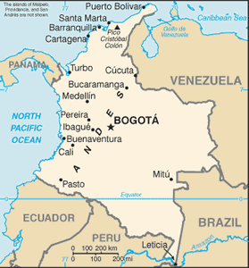
The Geography of Colombia
The Geography of Colombia
Colombian Geography
Location: Northern South America, bordering the Caribbean Sea, between Panama and Venezuela, and bordering the North Pacific Ocean, between Ecuador and Panama
Geographic coordinates: 4 00 N, 72 00 W
Map references: South America
Area: total: 1,138,910 sq km land: 1,038,700 sq km water: 100,210 sq km note: includes Isla de Malpelo, Roncador Cay, and Serrana Bank
Area - comparative: slightly less than twice the size of Texas
Land boundaries: total: 6,309 km border countries: Brazil 1,644 km, Ecuador 590 km, Panama 225 km, Peru 1,800 km, Venezuela 2,050 km
Coastline: 3,208 km (Caribbean Sea 1,760 km, North Pacific Ocean 1,448 km)
Maritime claims: territorial sea: 12 nm exclusive economic zone: 200 nm continental shelf: 200 m depth or to the depth of exploitation
Climate: tropical along coast and eastern plains; cooler in highlands
Terrain: flat coastal lowlands, central highlands, high Andes Mountains, eastern lowland plains
Elevation extremes: lowest point: Pacific Ocean 0 m highest point: Pico Cristobal Colon 5,775 m note: nearby Pico Simon Bolivar also has the same elevation
Natural resources: petroleum, natural gas, coal, iron ore, nickel, gold, copper, emeralds, hydropower
Land use: arable land: 2.01% permanent crops: 1.37% other: 96.62% (2005)
Irrigated land: 9,000 sq km (2003)
Natural hazards: highlands subject to volcanic eruptions; occasional earthquakes; periodic droughts
Environment - current issues: deforestation; soil and water quality damage from overuse of pesticides; air pollution, especially in Bogota, from vehicle emissions
Environment - international agreements: party to: Antarctic Treaty, Biodiversity, Climate Change, Climate Change-Kyoto Protocol, Desertification, Endangered Species, Hazardous Wastes, Marine Life Conservation, Ozone Layer Protection, Ship Pollution, Tropical Timber 83, Tropical Timber 94, Wetlands signed, but not ratified: Law of the Sea
Geography - note: only South American country with coastlines on both the North Pacific Ocean and Caribbean Sea


