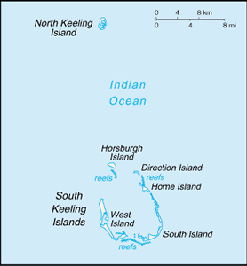
The Geography of Cocos (Keeling) Islands
The Geography of Cocos (Keeling) Islands
Cocos Islander Geography
Location: Southeastern Asia, group of islands in the Indian Ocean, southwest of Indonesia, about halfway from Australia to Sri Lanka
Geographic coordinates: 12 30 S, 96 50 E
Map references: Southeast Asia
Area: total: 14 sq km land: 14 sq km water: 0 sq km note: includes the two main islands of West Island and Home Island
Area - comparative: about 24 times the size of The Mall in Washington, DC
Land boundaries: 0 km
Coastline: 26 km
Maritime claims: territorial sea: 12 nm exclusive fishing zone: 200 nm
Climate: tropical with high humidity, moderated by the southeast trade winds for about nine months of the year
Terrain: flat, low-lying coral atolls
Elevation extremes: lowest point: Indian Ocean 0 m highest point: unnamed location 5 m
Natural resources: fish
Land use: arable land: 0% permanent crops: 0% other: 100% (2005)
Irrigated land: NA
Natural hazards: cyclone season is October to April
Environment - current issues: fresh water resources are limited to rainwater accumulations in natural underground reservoirs
Environment - international agreements:
Geography - note: islands are thickly covered with coconut palms and other vegetation; site of a World War I naval battle in November 1914 between the Australian light cruiser HMAS Sydney and the German raider SMS Emden; after being heavily damaged in the engagement, the Emden was beached by her captain on North Keeling Island


