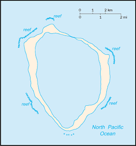
The Geography of Clipperton Island
The Geography of Clipperton Island
Geography
Location: Middle America, atoll in the North Pacific Ocean, 1,120 km southwest of Mexico
Geographic coordinates: 10 17 N, 109 13 W
Map references: Political Map of the World
Area: total: 6 sq km land: 6 sq km water: 0 sq km
Area - comparative: about 12 times the size of The Mall in Washington, DC
Land boundaries: 0 km
Coastline: 11.1 km
Maritime claims: territorial sea: 12 nm exclusive economic zone: 200 nm
Climate: tropical; humid, average temperature 20-32 degrees C, wet season (May to October)
Terrain: coral atoll
Elevation extremes: lowest point: Pacific Ocean 0 m highest point: Rocher Clipperton 29 m
Natural resources: fish
Land use: arable land: 0% permanent crops: 0% other: 100% (all coral) (2005)
Irrigated land: 0 sq km
Natural hazards: NA
Environment - current issues: NA
Environment - international agreements:
Geography - note: reef 12 km in circumference


