The Geography of Indonesia
The Geography of Indonesia
Indonesian Geography
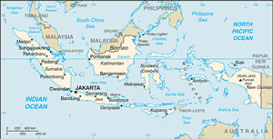
Location: Southeastern Asia, archipelago between the Indian Ocean and the Pacific Ocean
Geographic coordinates: 5 00 S, 120 00 E
Map references: Southeast Asia
Area: total: 1,919,440 sq km land: 1,826,440 sq km water: 93,000 sq km
Area - comparative: slightly less than three times the size of Texas
Land boundaries: total: 2,830 km border countries: Timor-Leste 228 km, Malaysia 1,782 km, Papua New Guinea 820 km
Coastline: 54,716 km
Maritime claims: measured from claimed archipelagic straight baselines territorial sea: 12 nm exclusive economic zone: 200 nm
Climate: tropical; hot, humid; more moderate in highlands
Terrain: mostly coastal lowlands; larger islands have interior mountains
Elevation extremes: lowest point: Indian Ocean 0 m highest point: Puncak Jaya 5,030 m
Natural resources: petroleum, tin, natural gas, nickel, timber, bauxite, copper, fertile soils, coal, gold, silver
Land use: arable land: 11.03% permanent crops: 7.04% other: 81.93% (2005)
Irrigated land: 45,000 sq km (2003)
Natural hazards: occasional floods; severe droughts; tsunamis; earthquakes; volcanoes; forest fires
Environment - current issues: deforestation; water pollution from industrial wastes, sewage; air pollution in urban areas; smoke and haze from forest fires
Environment - international agreements: party to: Biodiversity, Climate Change, Climate Change-Kyoto Protocol, Desertification, Endangered Species, Hazardous Wastes, Law of the Sea, Ozone Layer Protection, Ship Pollution, Tropical Timber 83, Tropical Timber 94, Wetlands signed, but not ratified: Marine Life Conservation
Geography - note: archipelago of 17,508 islands (6,000 inhabited); straddles equator; strategic location astride or along major sea lanes from Indian Ocean to Pacific Ocean


