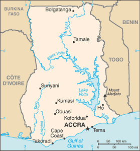
The Geography of Ghana
The Geography of Ghana
Ghanaian Geography
Location: Western Africa, bordering the Gulf of Guinea, between Cote d'Ivoire and Togo
Geographic coordinates: 8 00 N, 2 00 W
Map references: Africa
Area: total: 239,460 sq km land: 230,940 sq km water: 8,520 sq km
Area - comparative: slightly smaller than Oregon
Land boundaries: total: 2,094 km border countries: Burkina Faso 549 km, Cote d'Ivoire 668 km, Togo 877 km
Coastline: 539 km
Maritime claims: territorial sea: 12 nm contiguous zone: 24 nm exclusive economic zone: 200 nm continental shelf: 200 nm
Climate: tropical; warm and comparatively dry along southeast coast; hot and humid in southwest; hot and dry in north
Terrain: mostly low plains with dissected plateau in south-central area
Elevation extremes: lowest point: Atlantic Ocean 0 m highest point: Mount Afadjato 880 m
Natural resources: gold, timber, industrial diamonds, bauxite, manganese, fish, rubber, hydropower, petroleum, silver, salt, limestone
Land use: arable land: 17.54% permanent crops: 9.22% other: 73.24% (2005)
Irrigated land: 310 sq km (2003)
Natural hazards: dry, dusty, northeastern harmattan winds occur from January to March; droughts
Environment - current issues: recurrent drought in north severely affects agricultural activities; deforestation; overgrazing; soil erosion; poaching and habitat destruction threatens wildlife populations; water pollution; inadequate supplies of potable water
Environment - international agreements: party to: Biodiversity, Climate Change, Climate Change-Kyoto Protocol, Desertification, Endangered Species, Environmental Modification, Hazardous Wastes, Law of the Sea, Ozone Layer Protection, Ship Pollution, Tropical Timber 83, Tropical Timber 94, Wetlands signed, but not ratified: Marine Life Conservation
Geography - note: Lake Volta is the world's largest artificial lake


