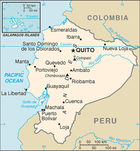
The Geography of Ecuador
The Geography of Ecuador
Ecuadorian Geography
Location: Western South America, bordering the Pacific Ocean at the Equator, between Colombia and Peru
Geographic coordinates: 2 00 S, 77 30 W
Map references: South America
Area: total: 283,560 sq km land: 276,840 sq km water: 6,720 sq km note: includes Galapagos Islands
Area - comparative: slightly smaller than Nevada
Land boundaries: total: 2,010 km border countries: Colombia 590 km, Peru 1,420 km
Coastline: 2,237 km
Maritime claims: territorial sea: 200 nm continental shelf: 100 nm from 2,500-m isobath
Climate: tropical along coast, becoming cooler inland at higher elevations; tropical in Amazonian jungle lowlands
Terrain: coastal plain (costa), inter-Andean central highlands (sierra), and flat to rolling eastern jungle (oriente)
Elevation extremes: lowest point: Pacific Ocean 0 m highest point: Chimborazo 6,267 m note: due to the fact that the earth is not a perfect sphere and has an equatorial bulge, the highest point on the planet furthest from its center is Mount Chimborazo not Mount Everest, which is merely the highest point above sea-level
Natural resources: petroleum, fish, timber, hydropower
Land use: arable land: 5.71% permanent crops: 4.81% other: 89.48% (2005)
Irrigated land: 8,650 sq km (2003)
Natural hazards: frequent earthquakes; landslides; volcanic activity; floods; periodic droughts
Environment - current issues: deforestation; soil erosion; desertification; water pollution; pollution from oil production wastes in ecologically sensitive areas of the Amazon Basin and Galapagos Islands
Environment - international agreements: party to: Antarctic-Environmental Protocol, Antarctic Treaty, Biodiversity, Climate Change, Climate Change-Kyoto Protocol, Desertification, Endangered Species, Hazardous Wastes, Ozone Layer Protection, Ship Pollution, Tropical Timber 83, Tropical Timber 94, Wetlands signed, but not ratified: none of the selected agreements
Geography - note: Cotopaxi in Andes is highest active volcano in world


