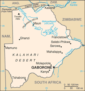
The Geography of Botswana
The Geography of Botswana
Motswana (singular), Batswana (p Geography
Location: Southern Africa, north of South Africa
Geographic coordinates: 22 00 S, 24 00 E
Map references: Africa
Area: total: 600,370 sq km land: 585,370 sq km water: 15,000 sq km
Area - comparative: slightly smaller than Texas
Land boundaries: total: 4,013 km border countries: Namibia 1,360 km, South Africa 1,840 km, Zimbabwe 813 km
Coastline: 0 km (landlocked)
Maritime claims: none (landlocked)
Climate: semiarid; warm winters and hot summers
Terrain: predominantly flat to gently rolling tableland; Kalahari Desert in southwest
Elevation extremes: lowest point: junction of the Limpopo and Shashe Rivers 513 m highest point: Tsodilo Hills 1,489 m
Natural resources: diamonds, copper, nickel, salt, soda ash, potash, coal, iron ore, silver
Land use: arable land: 0.65% permanent crops: 0.01% other: 99.34% (2005)
Irrigated land: 10 sq km (2003)
Natural hazards: periodic droughts; seasonal August winds blow from the west, carrying sand and dust across the country, which can obscure visibility
Environment - current issues: overgrazing; desertification; limited fresh water resources
Environment - international agreements: party to: Biodiversity, Climate Change, Climate Change-Kyoto Protocol, Desertification, Endangered Species, Hazardous Wastes, Law of the Sea, Ozone Layer Protection, Wetlands signed, but not ratified: none of the selected agreements
Geography - note: landlocked; population concentrated in eastern part of the country


