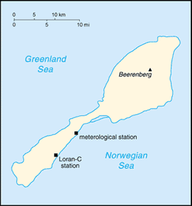
The Geography of Jan Mayen
The Geography of Jan Mayen
Geography
Location: Northern Europe, island between the Greenland Sea and the Norwegian Sea, northeast of Iceland
Geographic coordinates: 71 00 N, 8 00 W
Map references: Arctic Region
Area: total: 377 sq km land: 377 sq km water: 0 sq km
Area - comparative: slightly more than twice the size of Washington, DC
Land boundaries: 0 km
Coastline: 124.1 km
Maritime claims: territorial sea: 4 nm contiguous zone: 10 nm exclusive economic zone: 200 nm continental shelf: 200 m depth or to the depth of exploitation
Climate: arctic maritime with frequent storms and persistent fog
Terrain: volcanic island, partly covered by glaciers
Elevation extremes: lowest point: Norwegian Sea 0 m highest point: Haakon VII Toppen/Beerenberg 2,277 m
Natural resources: none
Land use: arable land: 0% permanent crops: 0% other: 100% (2005)
Irrigated land: 0 sq km
Natural hazards: dominated by the volcano Haakon VII Toppen/Beerenberg; volcanic activity resumed in 1970; the most recent eruption occurred in 1985
Environment - current issues: NA
Environment - international agreements:
Geography - note: barren volcanic island with some moss and grass


