The Geography of Uganda
The Geography of Uganda
Ugandan Geography
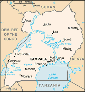
Location: Eastern Africa, west of Kenya
Geographic coordinates: 1 00 N, 32 00 E
Map references: Africa
Area: total: 236,040 sq km land: 199,710 sq km water: 36,330 sq km
Area - comparative: slightly smaller than Oregon
Land boundaries: total: 2,698 km border countries: Democratic Republic of the Congo 765 km, Kenya 933 km, Rwanda 169 km, Sudan 435 km, Tanzania 396 km
Coastline: 0 km (landlocked)
Maritime claims: none (landlocked)
Climate: tropical; generally rainy with two dry seasons (December to February, June to August); semiarid in northeast
Terrain: mostly plateau with rim of mountains
Elevation extremes: lowest point: Lake Albert 621 m highest point: Margherita Peak on Mount Stanley 5,110 m
Natural resources: copper, cobalt, hydropower, limestone, salt, arable land
Land use: arable land: 21.57% permanent crops: 8.92% other: 69.51% (2005)
Irrigated land: 90 sq km (2003)
Natural hazards: NA
Environment - current issues: draining of wetlands for agricultural use; deforestation; overgrazing; soil erosion; water hyacinth infestation in Lake Victoria; widespread poaching
Environment - international agreements: party to: Biodiversity, Climate Change, Climate Change-Kyoto Protocol, Desertification, Endangered Species, Hazardous Wastes, Law of the Sea, Marine Life Conservation, Ozone Layer Protection, Wetlands signed, but not ratified: Environmental Modification
Geography - note: landlocked; fertile, well-watered country with many lakes and rivers


