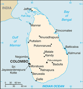
The Geography of Sri Lanka
The Geography of Sri Lanka
Sri Lankan Geography
Location: Southern Asia, island in the Indian Ocean, south of India
Geographic coordinates: 7 00 N, 81 00 E
Map references: Asia
Area: total: 65,610 sq km land: 64,740 sq km water: 870 sq km
Area - comparative: slightly larger than West Virginia
Land boundaries: 0 km
Coastline: 1,340 km
Maritime claims: territorial sea: 12 nm contiguous zone: 24 nm exclusive economic zone: 200 nm continental shelf: 200 nm or to the edge of the continental margin
Climate: tropical monsoon; northeast monsoon (December to March); southwest monsoon (June to October)
Terrain: mostly low, flat to rolling plain; mountains in south-central interior
Elevation extremes: lowest point: Indian Ocean 0 m highest point: Pidurutalagala 2,524 m
Natural resources: limestone, graphite, mineral sands, gems, phosphates, clay, hydropower
Land use: arable land: 13.96% permanent crops: 15.24% other: 70.8% (2005)
Irrigated land: 7,430 sq km (2003)
Natural hazards: occasional cyclones and tornadoes
Environment - current issues: deforestation; soil erosion; wildlife populations threatened by poaching and urbanization; coastal degradation from mining activities and increased pollution; freshwater resources being polluted by industrial wastes and sewage runoff; waste disposal; air pollution in Colombo
Environment - international agreements: party to: Biodiversity, Climate Change, Climate Change-Kyoto Protocol, Desertification, Endangered Species, Environmental Modification, Hazardous Wastes, Law of the Sea, Ozone Layer Protection, Ship Pollution, Wetlands signed, but not ratified: Marine Life Conservation
Geography - note: strategic location near major Indian Ocean sea lanes


